![](/images/other/stat-length.png)
![Tour Zu Fuß Gemeinde Alland - Allander Wanderweg 10 - Photo](https://media.geolcdn.com/t/1900/400/c3265708-7768-4297-a3cb-e6c840eda8bd.jpeg&format=pjpeg&maxdim=2)
Allander Wanderweg 10
SityTrail - itinéraires balisés pédestres
Tous les sentiers balisés d’Europe GUIDE+
![Länge](/images/other/stat-length.png)
Länge
9,4 km
![Maximale Höhe](https://static1.geolcdn.com/siteimages/upload/files/1508320355ic_sort_altitude_max_24dp.png)
Maximale Höhe
832 m
![Positive Höhendifferenz](https://static1.geolcdn.com/siteimages/upload/files/1508320355ic_sort_den_pos_24dp.png)
Positive Höhendifferenz
161 m
![Km-Effort](/images/other/stat-length.png)
Km-Effort
13,3 km
![Min. Höhe](https://static1.geolcdn.com/siteimages/upload/files/1508320355ic_sort_altitude_min_24dp.png)
Min. Höhe
290 m
![Negative Höhendifferenz](https://static1.geolcdn.com/siteimages/upload/files/1508320355ic_sort_den_neg_24dp.png)
Negative Höhendifferenz
682 m
![Boucle](https://static1.geolcdn.com/siteimages/upload/files/16400158638029165_repeat_loop_refresh_sync_direction_icon.png)
Boucle
Nein
Kennzeichnung
Erstellungsdatum :
2022-02-16 16:13:33.887
Letzte Änderung :
2022-03-03 04:32:04.023
![Zu Fuß](https://static1.geolcdn.com/sitytour/trail-icons/100.png)
3h01
Schwierigkeit : Einfach
![Scannen Sie diesen QR-Code, um die Tour in der SityTrail-Anwendung zu öffnen](https://capi.geolives.com/qq0zvz2zws4bq2lad0pu/sitytour/trails/3126473/qr.png?size=200)
Kostenlosegpshiking-Anwendung
Über SityTrail
Tour Zu Fuß von 9,4 km verfügbar auf Niederösterreich, Bezirk Baden, Gemeinde Alland. Diese Tour wird von SityTrail - itinéraires balisés pédestres vorgeschlagen.
Beschreibung
Trail created by Fremdenverkehrs- und Ortsverschönerungsverein der Großgemeinde Alland.
Symbol: 10 in orangen Punkt
Ort
Land:
Austria
Region :
Niederösterreich
Abteilung/Provinz :
Bezirk Baden
Kommune :
Gemeinde Alland
Standort:
Unknown
Gehen Sie:(Dec)
Gehen Sie:(UTM)
584680 ; 5317721 (33U) N.
Kommentare
Touren in der Umgebung
![Tour Zu Fuß Gemeinde Baden - Helenental - Purbachtal - Siegenfeld - Photo](https://media.geolcdn.com/t/375/260/5a614943-aefd-4044-ae93-346b84510ace.jpeg&format=jpg&maxdim=2)
![Zu Fuß Zu Fuß](https://static1.geolcdn.com/sitytour/trail-icons/100.png)
Helenental - Purbachtal - Siegenfeld
Zu Fuß
Einfach
Gemeinde Baden,
Niederösterreich,
Bezirk Baden,
Austria
![](/images/other/stat-length.png)
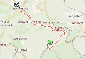
4,2 km | 5,8 km-effort
1h 18min
![](https://static1.geolcdn.com/siteimages/upload/files/16400158638029165_repeat_loop_refresh_sync_direction_icon.png)
Nein
![Tour Zu Fuß Sooß - Sooß - Hinterer Lindkogel - Photo](https://media.geolcdn.com/t/375/260/07679af8-2fd7-4614-800e-6519adbad7ed.jpeg&format=jpg&maxdim=2)
![Zu Fuß Zu Fuß](https://static1.geolcdn.com/sitytour/trail-icons/100.png)
Sooß - Hinterer Lindkogel
Zu Fuß
Einfach
Sooß,
Niederösterreich,
Bezirk Baden,
Austria
![](/images/other/stat-length.png)
4,3 km | 8,3 km-effort
1h 53min
![](https://static1.geolcdn.com/siteimages/upload/files/16400158638029165_repeat_loop_refresh_sync_direction_icon.png)
Nein
![Tour Zu Fuß Gemeinde Alland - Maria Raisenmarkt - Hoher Lindkogel - Photo](https://media.geolcdn.com/t/375/260/f28711c1-c58f-44b3-bc80-6633d2190f0e.jpeg&format=jpg&maxdim=2)
![Zu Fuß Zu Fuß](https://static1.geolcdn.com/sitytour/trail-icons/100.png)
Maria Raisenmarkt - Hoher Lindkogel
Zu Fuß
Einfach
Gemeinde Alland,
Niederösterreich,
Bezirk Baden,
Austria
![](/images/other/stat-length.png)
7,4 km | 12,9 km-effort
2h 55min
![](https://static1.geolcdn.com/siteimages/upload/files/16400158638029165_repeat_loop_refresh_sync_direction_icon.png)
Nein
![Tour Zu Fuß Gemeinde Alland - Augustinerhütte - Zobelhof - Photo](https://media.geolcdn.com/t/375/260/d4acc02f-48be-4d40-b654-ee5e1a7a248e.jpeg&format=jpg&maxdim=2)
![Zu Fuß Zu Fuß](https://static1.geolcdn.com/sitytour/trail-icons/100.png)
Augustinerhütte - Zobelhof
Zu Fuß
Einfach
Gemeinde Alland,
Niederösterreich,
Bezirk Baden,
Austria
![](/images/other/stat-length.png)
5,8 km | 9,3 km-effort
2h 7min
![](https://static1.geolcdn.com/siteimages/upload/files/16400158638029165_repeat_loop_refresh_sync_direction_icon.png)
Nein
![Tour Zu Fuß Gemeinde Heiligenkreuz - Cholerakapelle - Kalkgraben - Photo](https://media.geolcdn.com/t/375/260/42925560-1c0c-4861-8850-2a2d95fa07c0.jpeg&format=jpg&maxdim=2)
![Zu Fuß Zu Fuß](https://static1.geolcdn.com/sitytour/trail-icons/100.png)
Cholerakapelle - Kalkgraben
Zu Fuß
Einfach
Gemeinde Heiligenkreuz,
Niederösterreich,
Bezirk Baden,
Austria
![](/images/other/stat-length.png)
3,1 km | 7 km-effort
1h 35min
![](https://static1.geolcdn.com/siteimages/upload/files/16400158638029165_repeat_loop_refresh_sync_direction_icon.png)
Nein
![Tour Zu Fuß Gemeinde Baden - Beethoven Panoramaweg - Photo](https://media.geolcdn.com/t/375/260/d11d188e-e880-4a30-8e81-b48722b166a5.jpeg&format=jpg&maxdim=2)
![Zu Fuß Zu Fuß](https://static1.geolcdn.com/sitytour/trail-icons/100.png)
Beethoven Panoramaweg
Zu Fuß
Einfach
Gemeinde Baden,
Niederösterreich,
Bezirk Baden,
Austria
![](/images/other/stat-length.png)
5,3 km | 8,5 km-effort
1h 56min
![](https://static1.geolcdn.com/siteimages/upload/files/16400158638029165_repeat_loop_refresh_sync_direction_icon.png)
Nein
![Tour Zu Fuß Bad Vöslau - Beethoven Rundwanderweg - Photo](https://media.geolcdn.com/t/375/260/93a477f0-1654-4aa9-a0f9-f54798e8806b.jpeg&format=jpg&maxdim=2)
![Zu Fuß Zu Fuß](https://static1.geolcdn.com/sitytour/trail-icons/100.png)
Beethoven Rundwanderweg
Zu Fuß
Schwierig
Bad Vöslau,
Niederösterreich,
Bezirk Baden,
Austria
![](/images/other/stat-length.png)
26 km | 38 km-effort
8h 43min
![](https://static1.geolcdn.com/siteimages/upload/files/16400158638029165_repeat_loop_refresh_sync_direction_icon.png)
Ja
![Tour Zu Fuß Bad Vöslau - Bad Vöslau B5 Vöslauer Hütte - Photo](https://media.geolcdn.com/t/375/260/07679af8-2fd7-4614-800e-6519adbad7ed.jpeg&format=jpg&maxdim=2)
![Zu Fuß Zu Fuß](https://static1.geolcdn.com/sitytour/trail-icons/100.png)
Bad Vöslau B5 Vöslauer Hütte
Zu Fuß
Einfach
Bad Vöslau,
Niederösterreich,
Bezirk Baden,
Austria
![](/images/other/stat-length.png)
9,8 km | 13,9 km-effort
3h 9min
![](https://static1.geolcdn.com/siteimages/upload/files/16400158638029165_repeat_loop_refresh_sync_direction_icon.png)
Ja
![Tour Zu Fuß Gemeinde Alland - Raisenmarkt - Holzschlag - Peilstein - Photo](https://media.geolcdn.com/t/375/260/b38bf251-1d51-412b-a796-1cf470ade762.jpeg&format=jpg&maxdim=2)
![Zu Fuß Zu Fuß](https://static1.geolcdn.com/sitytour/trail-icons/100.png)
Raisenmarkt - Holzschlag - Peilstein
Zu Fuß
Einfach
Gemeinde Alland,
Niederösterreich,
Bezirk Baden,
Austria
![](/images/other/stat-length.png)
3,1 km | 6,5 km-effort
1h 28min
![](https://static1.geolcdn.com/siteimages/upload/files/16400158638029165_repeat_loop_refresh_sync_direction_icon.png)
Nein